Tech Support EX

  • Subscribe to our RSS feed.
  • Twitter
  • StumbleUpon
  • Reddit
  • Facebook
  • Digg
Showing posts with label Google Maps. Show all posts

Monday, 2 December 2013

The State of Colorado Puts Innovation First

Posted on 08:55 by Unknown
Posted by Kristin D. Russell, Secretary of Technology and State Chief Information Officer, Governor’s Office of Information Technology, State of Colorado

Editor's note: Colorado has enticed all sorts of pioneers since its Wild West beginnings. We’re excited to highlight a handful of these trailblazers - the intrepid entrepreneurs, aspiring micro-brewers and ambitious thought leaders - who have helped create the adventurous and innovative culture the Centennial State is known for. Today, we hear from Kristin D. Russell, Secretary of Technology and State Chief Information Officer for the State of Colorado’s Office of Information Technology.

The Colorado Governor’s Office of Information Technology (OIT) is leading an effort to transform government through the use of shared information technology services. As we shift from “business as usual” processes and tools towards innovative solutions that enable the efficient, effective, and elegant delivery of services, we look more and more to cloud-based services and solutions. In fact, we have published a “Cloud First” strategy for Colorado.

The move to Google Apps for Government in Colorado allowed us to replace our 15 siloed and disparate email systems, and the 50 servers supporting them, into a single, cloud-based solution. Now, not only do our more than 26,000 employees have a common email, calendar and collaboration system, they have the ability to work together on Google Docs, allowing teams to work together and share information across departments. This accessibility has also helped to enable a BYOD (bring your own device) program that lets employees work the way they want to work – even when they’re not sitting at their desks.

We are also taking advantage of Google Sites. Since Google Sites doesn’t require extensive web development skills, state agencies are now empowered to create helpful resources, both internally and externally, for a number of programs. TobaccoFreeCO.org, for example, was built on Google Sites and provides information on the effects of second-hand smoke and resources on quitting smoking. When unprecedented flooding devasted many areas of Colorado in recent months, we built a Google Map to help organize recovery efforts and then set up the ColoradoUnited.com website to provide the latest updates and provide an interactive way to assist flood victims as they rebuild.

Colorado Gov. John Hickenlooper often talks about the “three E’s” – making government more efficient, effective, and elegant. In Colorado we in the Governor’s Office of Information Technology are in the business of using innovative technology to accomplish just that.
Read More
Posted in #gonegoogle, Colorado, customer love, Google Apps for Government, Google Maps, google sites | No comments

Thursday, 21 November 2013

Google Maps helps Navman Wireless customers keep tabs on 190,000 fleet vehicles

Posted on 10:04 by Unknown
Posted by Paresh Nagda, VP of Engineering and CTO, Navman Wireless

Editor's note: Today we hear from guest blogger Paresh Nagda to find out how Navman Wireless, a global leader in GPS-based fleet optimization, uses Google Maps to monitor more than 190,000 vehicles for over 16,000 customers across five continents. This post is part of our series on the Transport and Logistics Industry and the ways they’re relying on Google Maps for Business to get people, products and assets to their destinations faster.
Fleet tracking & Google Maps--available wherever business demands
Every day, all over the world, millions of drivers hit the road to deliver goods and services. For our 16,000 customers – in dozens of sectors as diverse as mining, construction, transport, street cleaning and more – fleet monitoring is critical to their business success. Owning, operating and maintaining a vehicle fleet is a big expense, so more organizations are turning to advanced tools to maximize those assets. At Navman Wireless, our fleet optimization platform allows companies like Rio Tinto Group, Lloyds Pharmacy, JC Restoration, and Riviera Utilities to manage workers and keep track of important assets.

Before Google Maps, we had a hybrid solution – Microsoft Bing Maps combined with an in-house map engine. It was a drain on cost and engineering resources, and we struggled to keep data current. For example, map data updates required hours of our engineering team’s time; now with Google Maps, all updates are made automatically.

Google Maps was an obvious choice for us because it’s a cost-effective, reliable solution that works across geographies. We have customers in 14 countries who rely on us 100% to manage huge multimillion-dollar fleets, projects and logistics systems. With Google Maps, our customers see a visual display of their fleets constantly updated in real-time. One cool thing our customers love about Google Maps is the ability to use reverse geocoding to translate GPS data points into human readable addresses, so they can see where drivers are at all times.We can also draw polygons on maps to highlight customer sites, so they can see which trucks are coming and going.

Our customers can’t stop raving about Google Street View and traffic information. Dispatchers use Google Maps to get real-time traffic information and preview streets to help their drivers be more efficient. For example, a dispatcher could tell a driver to take a different route to avoid traffic, or to take a side road to deliver a package, since Street View shows the freight door is located on a back alley.

Using Google Maps has lots of benefits, but perhaps the best one is it just works — and that means we can focus on our work. Previously, 12-15% of our customer service calls were related to problems with our maps. Once we switched to Google Maps these calls went to almost zero. Our customers love how easy Google Maps are to use, and so does my engineering team. Quite simply, Google Maps helps make the Navman platform more effective, interactive and engaging for our customers.
Read More
Posted in customer love, Google Maps, Google Maps API, NAVMAN | No comments

Wednesday, 20 November 2013

Avoiding delays at the U.S.-Canada border, thanks to NITTEC and Google Maps

Posted on 10:16 by Unknown
Posted by Athena Hutchins, Executive Director, NITTEC

Editor's note: Today’s guest blogger is Athena Hutchins, executive director of the Niagara International Transportation Technology Coalition (NITTEC), a group of agencies improving traffic mobility and safety in Western New York and Southern Ontario. Join Athena on a webinar to hear the NITTEC story from her directly on December, 12 at 11-12 PST. Register here.

There’s a lot of traffic activity at the border of Western New York State and Southern Ontario: every month, an average of one million vehicles cross the three bridges with border checkpoints between the U.S. and Canada. Our job at Niagara International Transportation Technology Coalition (NITTEC) is to help vacationers and commuters in the Niagara Falls area see any traffic and road issues that might stand in their way. That’s why we created our new map — built with Google Maps — which takes a complex mix of data from local, state and federal agencies and gives drivers a single view of their trip.

We’ve used Google Maps on the NITTEC website since 2007. This year we developed a multilayered map as part of our efforts to improve traffic movement in the cross-border region. The new map uses the Google Maps API to help us pull together a wealth of useful data, including construction projects, delays and border crossing times. This information is available piecemeal from other agencies, but a traveler would have a hard time patching together a true picture of traffic conditions at the border, especially since we’re dealing with data from two countries.

The map is on the homepage of our new NITTEC website, so visitors can quickly find out how long it will take to get to the border, how much time they’ll have to wait at checkpoints and which alternate routes might be less congested. For instance, when the Lewiston-Queenston Bridge has long wait times, a quick glance at the map can tell drivers if they’re better off heading for the Peace Bridge or the Rainbow Bridge. Travelers can use the map’s control panel to choose which overlays they see, such as satellite views, highways, and live camera images.

To develop the new map, we incorporated 10 data feeds from across our 30 coalition agencies. The map refreshes every 20 seconds, using this constantly updated information. A mobile version of the map allows drivers approaching the border to get up-to-date info while they’re en route.

People are already familiar with Google Maps, so seeing our map provides clear, customizable and up-to-date traffic information that can be viewed at a glance and that’s easy to digest. It also helps us send a message about the NITTEC brand – that we’re on a mission to help people in the area get where they’re going safely and more efficiently.
Read More
Posted in customer love, Google Maps, Google Maps API, Google Maps for Business, Niagara International Transportation Technology Coalition | No comments

Monday, 18 November 2013

Google Maps for Business helps drive global growth for T Dispatch

Posted on 11:05 by Unknown
Posted by Mario Brandao, CTO of T Dispatch

Editor's note: Today's guest blogger is Mario Brandao, CTO of T Dispatch, a fast growing global provider of fleet management software. This post is part of our series on the Transport and Logistics Industry and the ways they’re relying on Google Maps for Business to get people, products and assets to their destinations faster.

If you’re like me, wherever you are in the world, you often depend on the knowledge of taxi and minicab drivers to get you where you want to be. And the firms that manage, equip and train these drivers are on a constant quest to improve the way their cars get around the many cities they travel around in. We started our company back in 2010 with the aim of creating an affordable mapping and dispatch technology that could be used by all sizes of fleet companies to become more efficient and more profitable.

Our clients tell us that drivers can spend around 30% of their time with the car empty; this is ‘dead’ mileage, which is costly and bad for the environment. We use Google Maps and an intelligent autodispatch algorithm to send jobs to the nearest driver, to find jobs within their catchment area and even to allocate jobs on their route home at the end of a shift. Controllers can create and dispatch a booking within 15 seconds, and we’re able to reduce time spent ‘empty’ by up to 50%.
We’ve found our clients love all the different features, too. The Google Tracks API makes it easy to pinpoint exactly where their drivers are at any one time, allowing jobs to be allocated more efficiently by dispatchers. And as this location data can be saved for up to ten years, clients can also use the technology to recognize trends and patterns and create more efficient processes in due course. Google’s snap-to-road tool even helps call centre dispatch managers to find out which side of the road the driver is on, which is especially helpful in some cities with complicated one way systems.

In the future we plan to integrate live weather reports, traffic information and use historical data to predict where busy areas will be, allowing fleets to anticipate where to send the drivers.

From a driver’s point of view, not only does the software help calculate the fastest route with the least mileage, but with Google Directions, drivers are able to calculate directions between locations before setting off, which prevents them from getting lost. Most importantly, most people are familiar with Google Maps and find it easy to use - which is important in a job when you’re often dealing with stressful circumstances like traffic and road closures.
Google Maps provides us with a comprehensive feature set too, so we’re able to offer our customers features like Directions as part of the package, which is a huge selling point for us. Furthermore, if we used some of the competition’s offering, every customer would have to pay a licensing fee but with Google this is avoided.

Google Maps has played a crucial role in helping us grow and move into new markets seamlessly - we’ve won clients across six continents, in over 30 different countries. I’m now looking forward to taking our technology with us to our next area of expansion - South America.

Read More
Posted in customer love, Google Maps, Google Maps API, Google Maps for Business, Google Maps Tracks API, T Dispatch | No comments

Smarter ways to plan and optimize transport and logistics with Google Maps for Business

Posted on 10:26 by Unknown
Posted by Elena Kelareva, Product Manager, Google Maps for Business

Editor's note: For transport companies, getting things from point A to point B in the safest, smartest and most efficient way is a top priority. This week we're showcasing the Transport and Logistics Industry and the ways they’re relying on Google Maps for Business to get people, products and assets to their destinations faster.

GPS technology and digital mapping have had a huge impact on making transport and logistics companies more efficient. This week we’ll be demonstrating innovative ways transport and logistics companies can use maps for smarter fleet and asset management, routing, tracking and planning. To kick things off, we’re announcing a new snap-to-road feature of the Google Maps Tracks API that can help organizations gain access to valuable data about where they’ve been.

Launched last year, Google Maps Tracks API allows users to store, display and analyze GPS data on a map. For a shipping company with a fleet of delivery trucks, for instance, the Tracks API offers a way to record all the routes and places its vehicles have traveled to and from. Stored in the Google cloud and visualized on a Google Map, fleet managers can access their information reliably, securely and using a map interface they’re familiar with.

With snap-to-road, transport and logistics companies can have an even more accurate view of their GPS information. Based on GPS data points, it identifies the most likely road a truck has been traveling on and plots the route on a map. This allows an organization to easily decipher driver behaviors and routing trends.
The images above show the same GPS data from a delivery truck before and after applying snap-to-road. With snap-to-road, the delivery route is correctly shown on a Google map, indicating that the driver traveled down a major highway.
For a transport company, having more accurate ways to track and understand GPS data means they can plan and predict routing and logistics with greater precision. Contact our sales team for more information about the Tracks API and how Google Maps for Business solutions can help your business.
Read More
Posted in Google Maps, Google Maps API, Google Maps for Business, Transport and Logistics | No comments

Wednesday, 23 October 2013

The Census Bureau puts every American on the map

Posted on 07:26 by Unknown
Posted by Dan Israel, Google Enterprise team

Each decade, the U.S. Census Bureau has the lofty challenge of counting every single person in America—308,745,538 of us as of 2010. Census employees go to great lengths to get the count as precise as possible because this data is used for everything from setting voting districts—from local school boards to Congress—to directing all government spending based on population.

In addition to the widely-known decennial census, the bureau does many other surveys of U.S. households and businesses. As a result, the Census has become a massive data warehouse with terabytes of data about social and economic conditions in the country. This data belongs to the American people, so the goal is to make it as accessible as possible to them. Once upon a time, this data used to be presented in spreadsheets or statistical tables, which were extremely useful to people who were familiar with the Census data, but less accessible to the general public.

Starting with the 2010 Census, the Bureau decided to put the data on a map to make it interactive and easy to use for everyone from a fourth grader working on a research report to a city planner looking for housing trends in their town. The Bureau chose Google Maps as the platform upon which to publish the Census data. The familiar search box and intuitive navigation tools make it easy for visitors to its website to find the information they’re looking for. In the background, Google Maps quickly searches through the large volume of Census data and renders the desired map to a website visitor in milliseconds. The Census data comes alive as visitors zoom, pan and explore the different types of data on the map.

Google Maps enables the Census Bureau to paint a rich portrait of the country, which is available to anyone who visits census.gov. Hear more from the Census Bureau in this video:


Read More
Posted in customer love, Google Maps | No comments

Wednesday, 31 July 2013

Unemployment Insurance Fraud Detection in Iowa

Posted on 04:05 by Unknown
Posted by Gary Bateman, CIO, Iowa Workforce Development

Editor's note: Today’s guest blogger is Gary Bateman, CIO for the Iowa Workforce Development. Be sure to join Innovation for the Nation, a virtual summit featuring government customers, streaming live on July 31st and August 1st. And see what other organizations that have gone Google have to say.

In Iowa, our mission at Iowa Workforce Development (IWD) is to provide a comprehensive statewide system of employment services, education and regulations to ensure the economic security of Iowa’s workers, businesses and communities. An important part of our effort is to identify and prevent unemployment insurance fraud. Our efforts have cut the rate of fraud to less than 6%, but we are not satisfied to stop there.

Detecting and preventing unemployment insurance fraud is challenging because of the high volume of claims we receive. Often times, we’re not able to detect the discrepancy until after multiple payments have been made. This lag means the bad actors can take the money and move on, making it difficult and expensive to recover the payment. We went looking for technologies to provide an even better rate of fraud detection, allowing us to act faster to prevent this criminal activity and save the state money.

After a competitive bid process, we selected Fraud Detection as a Service (FDaaS) by Pondera Solutions, a Google Enterprise Partner, to help us identify and prevent improper payments. FDaaS is a Google-powered solution that uses Google Prediction API, Google Maps, Google Street View and Google Earth.

With FDaaS, suspicious claims are proactively flagged by the system, which alerts IWD employees about potentially fraudulent claims. The claims are plotted on a heatmap built on Google Maps to identify areas with the highest fraud incidents and determine where to put more investigative resources. We also use Google Street View to check the validity of businesses that submit claims. All of these data points are compiled into a custom, configured dashboard that helps us quickly examine claimants and employers to validate whether these claims are valid. This dashboard will replace many of our manual processes of checking disparate databases. And because Google helps to integrate relevant market data into our validation processes, we can parse massive amounts of data quickly and efficiently, allowing us to identify advanced schemes and rapidly respond to potential issues. With all this information available at our fingertips, we can then examine claimants and employers to validate whether these claims are proper much more efficiently.

Using the new solution, IWD will improve accuracies in Unemployment Insurance, benefiting both the employers and citizens of Iowa. Our continuing efforts will help assure that the vast majority of unemployment insurance benefits are delivered to the citizens who need and deserve our assistance.
Read More
Posted in customer love, Google Earth, Google Maps, government | No comments

Thursday, 27 June 2013

GeoDigital helps keep power flowing with Google Maps Engine

Posted on 11:03 by Unknown
Posted by Posted by Alastair N. Jenkins, President & Chief Executive Officer at GeoDigital

Editor's note: They power our homes and supply clean water - utility companies fulfill our most basic needs. This week we're showcasing the Utilities Industry and the ways they’re relying on Google Maps for Business to improve operations and keep the lights on. Today’s guest blogger is Alastair N. Jenkins from GeoDigital.

If you've ever pruned or weeded in your backyard, you've had a glimpse at what we do at GeoDigital. We help keep weeds and trees under control on nearly 300,000 miles of utility corridors so power lines stay clear and the electricity keeps flowing to homes and businesses across North America.

We don’t actually trim the vegetation, we record it. Keeping track of growing vegetation is a never-ending task and one that requires us to compile a lot of data. To organize and gain better insights from the information we collect, we rely on Google Maps Engine.

Maps Engine has become an integral part of our operations. Using LiDAR (Light Detection and Ranging) technology, we first survey the land and gather utility corridor data with specialized air and ground mapping services. We then turn this data into business intelligence that the utilities companies can use to plan vegetation management. They also use this information for compliance reporting to regulatory agencies.

To make this information easy to digest, we have integrated Google Maps Engine and Google Earth Pro with our Software as a Service (SaaS) solution. Users can view color-coded LiDAR imagery that depicts existing vegetation, projected tree growth, and other obstructions that may interfere with utility maintenance activities. Multiple Google Earth layers - including Borders and Labels, Places, Photos, Roads and 3D Buildings - provide context, so planners can make better, faster scheduling and deployment decisions, while analysts can more efficiently report on regulatory compliance. Mobile workers gain the same benefits using their phone or tablet. For the utility companies, getting this kind of information in an actionable format used to take months and now it can be just a matter of days.

With Google Maps Engine we’re at the forefront of the vegetation management and compliance markets, helping our utilities customers stay ahead of the weeds.
Read More
Posted in customer love, Google Maps, Google Maps Engine, Google Maps for Business, utilities | No comments

Wednesday, 26 June 2013

Sutton & East Surrey Water transforms its operations with Google Maps Coordinate

Posted on 10:59 by Unknown
Posted by Jeremy Heath, Network Manager, Sutton and East Surrey Water

Editor's note: They power our homes and supply clean water - utility companies fulfill our most basic needs. This week we're showcasing the Utilities Industry and the ways they’re relying on Google Maps for Business to improve operations and keep the lights on. Today’s guest blogger is Jeremy Heath from Sutton and East Surrey Water.

At Sutton and East Surrey Water (S&ESW), we supply water to almost 700,000 customers each year, stretching more than 2,000 miles. To manage such infrastructure for our day-to-day operations, quickly assigning and tracking jobs in the field is a top priority. Like many utility companies, we’ve relied heavily on paper-based work orders to manage customer service calls and repairs, a process that added extra work hours for our employees. Then we discovered Google Maps Coordinate.

Introducing Maps Coordinate to S&ESW’s meter fitting and repair teams allowed us to improve productivity and cut costs. Before every team would spend an hour at the end of the day filling out paperwork. Today, we can use the Google Maps Coordinate smartphone app to record data and build reports on a daily basis. Replacing our paper-based workflow with Maps Coordinate has resulted in a 17% increase in operational efficiency and an overall return on investment (ROI) of 500% based on time and cost savings.

Using the same technology as Google Maps, the Coordinate app provides our dispatchers and repair teams with a unified view of past and present job details. Our employees in the field can share their location, manage jobs and record data directly in the app. And because it incorporates the easy-to-use Google Maps interface and rich set of mobile features, we can provide our employees with a tool that is simple and familiar, minimizing training requirements.
Without the need for complex configurations, adopting Coordinate’s web and mobile app was simple and easy to do for our employees. Since we were able to run Maps Coordinate on our existing smartphone network and back-end technology, we deployed the mobile and web-based apps across S&ESW within weeks. This helped us to further reduce development time and costs.

Integrating Google Maps has changed the way we communicate and operate our business. Its allowed us to achieve an impressive ROI and save thousands of dollars in printing costs alone. Above all, we’re meeting demands for better quality service and providing the clean water that our customers depend on everyday.
Read More
Posted in customer love, Google Maps, Google Maps Coordinate, Google Maps for Business, utilities | No comments

Tuesday, 25 June 2013

Helping GE visualize its world with Google Maps for Business

Posted on 11:27 by Unknown
Posted by Bryan Friehauf, product line leader-software solutions for GE’s Digital Energy business

Editor's note: They power our homes and supply clean water - utility companies fulfill our most basic needs. This week we're showcasing the Utilities Industry and the ways they’re relying on Google Maps for Business to improve operations and keep the lights on. Today’s guest blogger is Bryan Friehauf from GE.

Electric companies are responsible for providing safe, reliable energy to thousands of households. At GE’s Digital Energy business, we know our utility customers have a big job to do and are constantly looking for efficient ways they can meet growing energy demands.

To help our clients improve mission-critical operations, we’ve developed a suite of applications for the utility industry. GE’s Smallworld™ technology brings users smarter ways to plan and design networks, manage jobs in the field and visualize assets using Google Maps. With access to Google’s mapping tools, we’re giving our customers location-based technology that is fully customized for their operations and easy for their employees to use.

By integrating the Google Maps API, GE’s Smallworld-powered Distribution and Outage Management Systems can display location-based information on a Google Map. With a GE device in-hand, a utility worker can see infrastructure that’s down in real-time and quickly respond to the situation. This gives our utility customers a portable solution for gaining information on-the-go.
In addition to having instant, mobile insights, our Smallworld applications give users access to data visualization on a map that is familiar and accurate. Teams in the field can use features like Google Street View, helping them more efficiently locate assets that are hard to uncover, such as transmission lines, or a repair job.

From planning electric, gas and water distribution systems to designing telecommunications networks, having the right tools to visualize and manage complex infrastructure is critical for today’s utility industry. But with Google Maps integrated as part of our applications, we’re making it a little easier.
Read More
Posted in customer love, GE, Google Maps, Google Maps API, Google Maps for Business, utilities | No comments

Monday, 24 June 2013

GrDF builds its customer pipeline with Google Maps for Business

Posted on 13:08 by Unknown
Posted by Pascale Bernal, CIO of Gaz réseau Distribution France (GrDF)

Editor's note: They power our homes and supply clean water - utility companies fulfill our most basic needs. This week we're showcasing the Utilities Industry and the ways they’re relying on Google Maps for Business to improve operations and keep the lights on. Today's guest blogger is Pascale Bernal, CIO of Gaz réseau Distribution France (GrDF). 

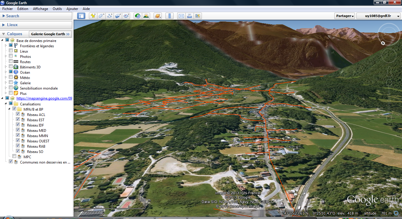
The GrDF natural gas pipeline is 194,600 kilometers (120,900 miles) long. In other words, it’s almost five times longer than the circumference of the earth. Google Maps for Business has made it possible for us at GrDF to manage every detail of that network and build on top of it.

In less than six months, we used Google Maps for Business, including Google Maps Engine and Google Earth, to import and organize more than 18 million data points about our pipeline. Google’s map solutions helped us create Gazm@ps Raccordabilité, an online platform that better serves our customers, technicians and partners.

Gazm@ps helps us run more efficiently by providing our sales, marketing and technical teams with continuously updated views of streets and municipalities served by GrDF. Each day, more than 1,000 employees access customer locations, geographic coordinates, Google Maps Street View, and municipality information through the familiar Google Maps interface. Our natural gas technicians use Google Earth’s 3D maps in Gazm@ps to plan installation and service work before they go out into the field. We also use Google Maps for Business to combine our geographic information system and customer relationship management systems inside Gazm@ps. With one click our salespeople can instantly see anything they need to know about a potential customer’s property, including location, coordinates and Street View. This costs 60 percent less than our previous customer relationship management system.


Prospective customers use Gazm@ps when they visit our customer website and enter their address to instantly find out if they are eligible for GrDF service. Each eligible customer is connected with a salesperson who can access relevant information, including a Street View of the service location and details about the municipality they live in. Since we launched Gazm@ps in July 2012, our user base has grown by 30 percent per quarter and the site now accounts for 10 percent of GrDF’s overall site traffic.

We’re also using Google Maps for Business to create Gazm@ps System, an external site that will help heating and plumbing service providers, home builders and local authorities access our mapping data. Using Google Maps to share this information is much easier than the expansive spreadsheets we used before. We’re also developing Gazm@ps Zio, a tool for infrastructure operators that verifies mapping data the partners send to the government for its national database of power distribution, sewerage and telecommunications systems in France.

We serve more than three-quarters of the French population while managing vast amounts of infrastructure, so having accurate, easily accessible data about our pipelines and our customers is essential. While we connect all the pipes underground, we use Google Maps for Business to help us better connect with our new and old customers above the ground.
Read More
Posted in customer love, Google Maps, utilities | No comments

Empowering today’s utility industry with Google Maps for Business

Posted on 12:14 by Unknown
Posted by Tarun Bhatnagar, Director, Google Maps for Business

Editor's note: They power our homes and supply clean water - utility companies fulfill our most basic needs. This week we're showcasing the Utilities Industry and the ways they’re relying on Google Maps for Business to improve operations and keep the lights on. 

Utility companies have a lot of information and assets to manage. From water to electric power, demand for clean, reliable energy is at an all-time high. This puts even more pressure on the industry to find the best solution for improving operations, whether it's integrating simple asset management, investing in visualization tools or integrating real-time communications with customers.

Google Maps for Business brings the power of Google Maps and Google Earth to an organization improving decision making, optimizing operations and creating engaging applications. Its scalable, familiar technology offers a diverse set of map applications, APIs and cloud-enabled tools that are fully customizable. When applied to utilities companies, Google’s enterprise mapping solutions can let organizations see their data layered on a Google Map and securely share this information with employees, key stakeholders and the public.

This week you’ll hear from several leaders in the utilities space who are using maps to solve industry challenges. By adopting Google Maps for Business, these companies are changing the way they manage jobs, streamline and consolidate processes and better engage with their customers. You’ll hear stories from companies around the globe who have opted for easy-to-use mapping technologies as a way to optimize operations.

Check back here this week and learn more about how today’s utilities are realizing the benefits of Google Maps for Business.
Read More
Posted in Google Maps, utilities | No comments

Wednesday, 5 June 2013

FedEx.com re-imagined with Google Maps Engine

Posted on 12:02 by Unknown
Posted by Pat Doyle, Manager IT, FedEx

Editor's note: Today we announced the availability of the Google Maps Engine API, letting organizations build their own applications on Google’s cloud infrastructure. Hear from guest blogger, Pat Doyle, to find out how FedEx helps its customers locate their nearly 50,000 retail touchpoints on FedEx.com, using Maps Engine.

Delivering packages to almost any location in the world is just another day on the job at FedEx. On average, we ship more than nine million packages daily and guarantee they’ll arrive on-time, at the right place and unharmed. However, our commitment to a superior customer experience extends far beyond delivering packages. To make it even easier for people to find the information they need online, we launched a new store locator site using Google Maps.

Using Google Maps, and more specifically Google Maps Engine, allowed us to completely re-imagine FedEx.com. We turned to Maps Engine because it gave us a powerful platform to build and share our own FedEx maps. By integrating features that so many people use everyday, like Google Street View and driving directions, FedEx.com visitors can easily find the nearest FedEx.

In addition to providing a much easier way to locate us, Google Maps Engine gives us another big advantage: global accuracy and consistency. Central to the cloud-based offering, we can rely on Google’s core infrastructure to host our always-changing and growing database of store information. By hosting attributes, such as street addresses, opening hours, holiday schedules and local pick-up times on Maps Engine, we can update details for nearly 50,000 retail touchpoints in real-time and share this information to FedEx.com visitors within minutes. This helped us replace a patchwork of region-bound store locators with a single, global site.


Providing a store locator that is easy-to-use, accurate and reliable helps us deliver a brand experience that our customers can trust. Google Maps Engine is critical to better customer service and it helps users quickly find and access our stores online. With our new store locator, powered by the Google Maps Engine, we can concentrate on what FedEx does best - delivering packages on-time.
Read More
Posted in customer love, FedEx, Fedex.com, Google Maps, Google Maps API, Google Maps Engine | No comments

Google Maps Engine: Changing the way enterprises create and use maps

Posted on 08:59 by Unknown
Posted by Jen Kovnats, Product Manager, Google Maps for Business

Maps tell stories about the world around us. With a single map, an organization can locate underground pipelines, decide on the best place to build their next store, or inform customers about cell phone coverage areas. Today we're announcing the Google Maps Engine API, allowing developers to bring the power of Maps Engine into their own applications.

Maps Engine lets organizations use Google’s fast and reliable cloud infrastructure to layer their data on top of a Google Map and share their custom-made Google Maps with employees, customers or the public-at-large. At the push of a button an organization can share their maps internally or publish them on the web, making it easy to access their data from anywhere.

The API provides direct access to Maps Engine for reading and editing spatial data hosted in the cloud. With the API, organizations can develop on any platform - web, Android, iOS and server-to-server - and build applications like store locators, crowdsourced maps or crisis-response maps. For example, FedEx.com uses the API to query its more than 50,000 retail locations and IRIS creates applications for utilities to track underground pipelines.

Google Maps Engine is changing the way enterprises create and use maps - replacing complex GIS technologies with accurate and comprehensive Google Maps-based tools. Contact sales if you are interested in Google Maps Engine or learn more about today’s newly launched API.


Read More
Posted in FedEx, Google Maps, Google Maps API, Google Maps Engine | No comments

Tuesday, 4 June 2013

Travis County Sheriff’s Office helps to ensure officer safety with Google Maps Coordinate

Posted on 06:44 by Unknown
Posted by Jim Sylvester, Travis County Sheriff’s Office

Editor's note: Today’s guest blogger is Jim Sylvester, Deputy Chief, Travis County Sheriff’s Office. When the Travis County Sheriff’s Office needed to track officer's positions and dispatch additional aid, they turned to Google Maps and Google Maps Coordinate. See what other organizations that have gone Google have to say.

I’ve spent 27 years working for the Travis County Sheriff’s Office in Austin, Texas, and I’m a third-generation law enforcement officer. Since I’ve been on the job, the county population has nearly tripled in size from about half a million to approximately 1.3 million citizens today. We consider ourselves a family at the Sheriff’s Office, and my paramount concern is keeping our law enforcement officers safe so they can protect the county’s citizens.

Until recently, we didn’t have technology that could give us the precise location of our deputies, which made it difficult to ensure their safety at all times. For instance, when deputies left their patrol cars to pursue a suspect on foot, we were not able to track their movements in real-time to dispatch additional assistance. For that reason, we decided to try Google Maps Coordinate.


It didn't take long for the team to pick it up: our deputies needed less than 10 minutes of instruction before they were ready to start using the product themselves. We put it to the test during the Formula One U.S. Grand Prix weekend in Austin in November 2012, which drew more than 120,000 attendees. With Google Maps Coordinate running across all our devices, our dispatchers were able to interface and organize the deputies throughout the event in real-time. Our personnel knew the exact locations of all available law enforcement resources in the area at any given moment.

What we saw at the Formula One event has prepared us for the future, and we’re making this a regular part of our toolset to fully maximize officer safety while serving our citizens. We plan to use this product at the Republic of Texas biker rally in Travis County this June, which will draw a huge crowd. We also plan to use it for more special events and also daily to keep deputies safe while they are on bike or foot patrols.

Thanks to Google Maps Coordinate, we feel much more in sync and aware of the situation at hand, and—above all—we have better ways to safeguard our law enforcement officers.
Read More
Posted in #gone google, customer love, Google Maps, Google Maps Coordinate | No comments

Thursday, 30 May 2013

Google Maps Helps Trulia Put Some Heart into Home Buying

Posted on 06:57 by Unknown
Posted by Jeff McConathy, VP Engineering at Trulia

Editor's note: Our guest blogger is Jeff McConathy, Vice President of Engineering, Consumer Services, at Trulia, a San Francisco-based company that gives home buyers, sellers, owners and renters the inside scoop on properties, places and real estate professionals. See what other organizations that have gone Google have to say.

There is an old saying in real estate: it’s all about location, location, location. With this in mind, it’s natural that maps are key to the success of any real estate business. They’re the first real guidepost that homebuyers look at when searching for a new home. At Trulia, we want our maps to do more. Maps are the canvas that let us tell the story of every property on our site – not just where it is, but what the neighborhood is like, how safe it is, the quality of the schools, how long it takes to commute to work and more. By using the Google Maps API for Business, we’re able to connect bits of data with home listings to give the 31.4 million people who visit Trulia each month a complete picture of a potential new home before they ever step inside it.

Google Maps API is core to Trulia’s user experience. It’s the common interface that lets homebuyers search for and browse through properties, explore neighborhoods, and jumpstart their home buying process. We’ve been working with Google since 2005, after we gave both Google Maps and Microsoft Virtual Earth a trial run. Google Maps proved to be the easiest to customize and had the best functionality. Since then, our partnership has grown seamlessly – Google constantly adds new features to the API and we update our maps weekly.


Google Maps let us visualize data in a context that’s important to homebuyers. Instead of a list of crime statistics, we can create a color-coded heat map where our users can look around the city or town they’re exploring and compare neighborhoods, or even streets that are close to each other. We can present home buyers, sellers, and renters data about schools, public transit, nightlife, environmental and natural disaster risks, property valuations, and sales trends.


Google Maps also lets Trulia run efficiently on all mobile platforms. In addition to our mobile site, we have 14 different apps for homebuyers, agents, renters, mortgage representatives and more, with over 11 million mobile users each month. The Google Maps API ensures that we have full functionality across all of our apps, no matter the platform.

Trulia’s business is built on providing insights to consumers who are looking for the right place to live and then connecting them to a real estate professional. Google Maps adds color and life to that process by giving us a platform to tell a story about a particular neighborhood or property. It gives users clarity and simplicity in what can be an extremely complicated and confusing process, and that’s the absolute most valuable thing we can offer our users.
Read More
Posted in #gone google, #gonegoogle, customer love, Google Maps, Google Maps API | No comments

Thursday, 23 May 2013

New European Lexus IS: Providing smarter destination information with Google

Posted on 04:06 by Unknown
Posted by Pierre Masai, VP Information Systems and Telematics, Toyota Motor Europe

Editor's note: Today’s guest blogger is Pierre Masai, VP Information Systems and Telematics from Toyota Motor Europe. He talks about the next generation navigation system in the new Lexus IS, available from mid 2013 across Western and Eastern Europe. Hear how the company’s newest technology is using Google features to create improved experiences for its drivers.

At Lexus, we value bringing the newest technology to our drivers. We want Lexus drivers to depend on their cars for accurate, up-to-date information about their surroundings. We've entered a new generation of in-car technology and we're rolling out several features from Google Maps to enhance our driver’s navigation experience.

The Lexus IS newest in-dash system gives users direct access to Google local search, Street View and geotagged photos from Panoramio. From cafés in Rome to museums in Paris, drivers can use their navigation system to search online for points of interest. With access to continually updated local information powered by Google, this gives Lexus users peace of mind.

We're also excited to announce that Street View and Panoramio will be integrated in Lexus’ premium in-car technology. For the first time, Lexus drivers will be able to see real-life images of their surroundings, guiding them to nearby places.


As we continue to bring smarter technology to our cars, drivers will find the most relevant information they need, when they need it most. Now Lexus drivers can have access to map features with Google, ensuring a much more informed drive wherever they’re going.
Read More
Posted in #gone google, #gonegoogle, customer love, Google Maps | No comments

Friday, 10 May 2013

Clarion helps drivers find their way

Posted on 13:21 by Unknown
Posted by Yoshihisa Matsuoka, Executive General Manager of Marketing at Clarion

Editor's note: Our guest blogger is Yoshihisa Matsuoka, Executive General Manager of Marketing at Clarion, a global producer of in-car audio-visual and navigation systems used by car manufacturers around the world. See what other organizations that have gone Google have to say.

As makers of in-car navigation and infotainment systems, we work to give our customers access to the most accurate and up-to-date information when they’re behind the wheel. Whether they’re exploring places in a new city, or discovering local gems in their hometown, we believe they should be able to find what they’re looking for quickly, easily and safely.

To give drivers access to even more information where and when they need it, we’ll soon be integrating Google Places, Send-To-Car and Voice Search into our new Smart Access cloud based infotainment system. The Google Places API will provide drivers with access to a rich and constantly refreshed database of over over 80 million restaurants, stores and other points of interest to explore. Send-to-Car will allow drivers to send a Google Maps destination like a restaurant, store or park, directly to their car’s Smart Access system. And with Google Voice Search, drivers will be able to safely discover destinations by speaking their queries instead of having to type them.


Smart Access is designed to give drivers the most secure and comfortable in-car experience, and Google’s APIs are just some of the features that we’ll be integrating into this innovative system. We look forward to being able to offer drivers around the world access to this connected driving experience when we launch Smart Access this fall.
Read More
Posted in #gone google, #gonegoogle, customer love, Google Maps | No comments

Tuesday, 26 March 2013

San Francisco 49ers uses Google Maps Coordinate to tackle pre-game logistics

Posted on 11:09 by Unknown
Posted by Dan Cory, Director of Security, San Francisco 49ers

Editors Note: Our guest blogger this week leads the security efforts for the San Francisco 49ers. See how the security team uses Google Maps Coordinate as a way to more effectively manage pre-game logistics and protect one of San Francisco’s most beloved organizations.

For the San Francisco 49ers, team communication is everything. From third down plays to stadium security, being able to get in touch with the right people at the right time is critical. As Director of Security, I’m responsible for helping the 49ers get to where they need to be, as quickly and as safely as possible. Google Maps Coordinate, a workforce management tool, helps us run a smooth, safe operation behind the scenes, so our players, coaches and staff can focus on the game.

Our team relies on the Google Maps Coordinate mobile app to manage pre-game logistics. The app lets me use my phone to send accurate information to staff in a simple, straightforward way. When we’re on the road and one of the players needs a ride back from the workout facility to the hotel, Maps Coordinate shows me which of my drivers is available and nearby to complete the transportation task. Moreover, it provides a visual communication tool, showing the real-time location of our security team on a Google Map.

Using Google Maps Coordinate, I can easily assign or reassign jobs to team members, anytime, anywhere. When one of our team members accepts, checks-in or completes a task, I can immediately see details of the job and its status. This complements our existing radio network, saving airtime and providing an alternative way to relay information, give instructions or find out where people are.

While preparing for the biggest game of the year, Google Maps Coordinate provided us with the foundation for establishing a 24/7 control center in New Orleans. Within a two-week period, approximately 150 jobs were created to manage pre-game logistics of our designated security escorts. This enabled us to safely transport our players, coaches and staff to various locations across the city. Additionally, the familiarity and accuracy of Google Maps allowed our team to more efficiently maneuver in high-traffic and unknown areas.

NFL game days are a bit more intense for me than the average 49ers fan. But using Google Maps Coordinate lets me and the team focus on what really matters - another winning season.
Read More
Posted in customer love, Google Maps, Google Maps Coordinate | No comments

Thursday, 28 February 2013

Bringing the power of Google Maps Engine to Envista’s IRIS platform

Posted on 09:22 by Unknown
Posted by Mark Prestipino, CEO at Envista

Editor's note: Our guest blogger this week is Mark Prestipino, Envista CEO. Looking for ways to provide enhanced map capabilities to its utilities customers, Envista talks about integrating Google Maps Engine into its IRIS technology. See what other organizations that have gone Google have to say.

With miles and miles of underground pipeline and transmission lines to manage, the ability for our utility customers to quickly locate and keep track of their assets is vital to running a successful operation. Thanks to Google Maps Engine, we've been able to create a powerful map platform that makes this all possible.

IRIS, our newest solution for the utility industry, is a cloud-based Platform-as-a-Service (PaaS) technology that allows an organization to develop custom map applications without the need for complex coding. Incorporating an organization’s business and location data into a single platform, IRIS apps provides the location-relevant information needed to efficiently maintain critical assets in the field.


The secret behind our IRIS technology is Google Maps Engine, which gives our customers three key benefits:

  • Scale: Founded on Google’s core infrastructure, Google Maps Engine provides IRIS users with unrivaled scale and reliability. This enables the information and image-processing power needed to store, manage and publish maps with layers and layers of high resolution geospatial data. 
  • Familiarity: IRIS apps users can see their data visualized on a Google Map. This simple user interface -- combined with the incredible, up-to-date imagery of Google Earth -- lets people build their own map applications and understand what they see on a map with very little training. 
  • Mobility: With pipeline and asset management primarily taking place in the field, access to map data anytime, anywhere is critical. The Google Maps Engine cloud platform allows IRIS maps to be used in almost any environment -- mobile, remote or offline.

Maps are an invaluable tool for the utilities industry -- and so is scalable, simple-to-use technology. When it comes to providing our utilities customers with a map solution they can rely on, Google Maps Engine is the clear choice for us.
Read More
Posted in customer love, Customer testimonial, Google Maps, Google Maps Engine | No comments
Older Posts Home
Subscribe to: Posts (Atom)

Popular Posts

  • Keeping you safe in 2013
    Posted by Eran Feigenbaum, Director of Security, Google Enterprise Most businesses these days rely on technology to get their work done. An...
  • GeoEye Using Google Earth Builder for Commercial Distribution of their Data
    Posted by Dylan Lorimer, Google Earth and Maps for Business Product Manager Since 2008, Google has worked with GeoEye to publish millions ...
  • Mapping a clear strategy for business growth with Google
    Posted by A.V. Dharmakrishnan, Chief Executive Officer, Madras Cements Editor's note: Today’s guest is A.V. Dharmakrishnan, Chief Exec...
  • Third-party apps: now easier to find and more secure
    Posted by Apoorv Saxena, Product Manager, Google Apps for Business There are thousands of third-party applications that integrate with Goog...
  • FedEx.com re-imagined with Google Maps Engine
    Posted by Pat Doyle, Manager IT, FedEx Editor's note: Today we announced the availability of the Google Maps Engine API , letting organ...
  • Artwork powered by Chromebooks at the Polaroid Fotobar
    Posted by George Garcia, CIO, TWS Partnership Editor's note: Today’s guest blogger is TWS Partnership’s Chief Information Officer, Geo...
  • Playworks Transforms more than Recess with Chromebooks and Apps
    Posted by Richard Ng, IT director, Playworks Editors note: Today’s guest blogger is Richard Ng, IT director at Playworks, a nonprofit organ...
  • Graduation Alliance deploys Chromebooks to help at-risk students earn diplomas
    Posted by Gregg Rosann, President, Co-Founder and Chief Technology Officer, Graduation Alliance Editor's note: Today’s guest blogger is...
  • GHouse has gone Google
    Posted Tim Luckow, Founder & Owner of GHouse Editor's note: From the founding of Faneuil Hall in 1740 to the opening of Franklin So...
  • Google Apps for Education helps Pt England School raise achievement levels
    Posted by Dorothy Burt, professional development leader at Pt England School Editors note: Today’s guest blogger is Dorothy Burt, a profess...

Categories

  • #gone google
  • #gonegoogle
  • #Google Apps
  • #innovationupgrade
  • #moregoogleapps
  • #SysAdminDay
  • #tbt
  • #throwbackthursday
  • #top10trust
  • 100% web
  • admin
  • admin sdk
  • Android
  • Apps
  • Apps Adventures
  • Asia Pacific
  • Audi
  • Audi Connect
  • Australia
  • big data
  • Big Query
  • bigquery
  • Boston
  • browser
  • Chrome
  • Chrome for Business
  • Chrome Frame
  • Chrome OS
  • chromebooks
  • Chromebooks for Education
  • chromebox
  • City 24/7
  • Clearing Kosovo
  • Cloud
  • cloud computing
  • cloud computing gonegoogle
  • cloud computing gonegoogle Google Apps
  • cloud computing gonegoogle Google Apps google docs small business success story
  • cloud computing gonegoogle Google Apps google docs small business success story switch
  • cloud datastore
  • cloud platform
  • cloud print
  • cloud services
  • cloud sql
  • collaboration
  • Colorado
  • contacts
  • customer love
  • Customer story
  • Customer testimonial
  • Developer
  • developers
  • Docs
  • documents
  • drive storage
  • Earth
  • earth and maps
  • education
  • enterprise
  • events
  • FedEx
  • Fedex.com
  • franchises
  • Gartner
  • GE
  • Global Partner Summit
  • gmail
  • Gone Google
  • gonegoogle
  • Google App Engine
  • Google Apps
  • Google Apps Blog
  • Google Apps Engine
  • Google Apps for Business
  • google apps for education
  • Google Apps for Government
  • Google Apps Reseller
  • Google Apps Script
  • Google Apps Vault
  • Google Calendar
  • Google Cloud Platform
  • google cloud storage
  • google commerce search
  • Google Compute Engine
  • google docs
  • google drive
  • Google Earth
  • Google Earth Enterprise
  • Google Earth Pro
  • Google Enterprise
  • Google Enterprise Search
  • Google Forms
  • Google Green
  • google groups
  • Google Maps
  • Google Maps API
  • Google Maps Coordinate
  • Google Maps Engine
  • Google Maps Engine public data program
  • Google Maps for Business
  • Google Maps Tracks API
  • Google Places API
  • google play for education
  • Google Prediction API
  • Google Search Appliance
  • google sites
  • Google spreadsheets
  • google storage
  • Google Storage for Developers
  • google+
  • Google+ api
  • Google+ Communities
  • googlenew
  • government
  • GSA
  • GSA 7.0
  • guest post
  • HALO Trust
  • Hangout on Air
  • hangouts
  • innovation
  • international trade
  • Internet Explorer
  • intranet
  • iOS
  • iPad
  • IT
  • K-12
  • large business
  • manufacturing
  • Maps
  • marketplace
  • medium business
  • mobile
  • moms
  • Mother's Day
  • NAVMAN
  • new features
  • Niagara International Transportation Technology Coalition
  • non-profit
  • noteworthy
  • offline
  • partner
  • partners
  • Place Summaries
  • Postini
  • productivity
  • Quickoffice
  • Receptionist's Day
  • retail
  • SBW2013
  • Search
  • Security
  • Sheets
  • Slides
  • small business
  • SMB
  • success story
  • support
  • System Admin
  • T Dispatch
  • Transport and Logistics
  • Trust
  • university
  • utilities
  • Veteran Owned Businesses
  • Veterans Day
  • wallet
  • webinar

Blog Archive

  • ▼  2013 (239)
    • ▼  December (18)
      • Keeping you safe in 2013
      • Google+ Helps Premier Foods Elves Get Ready for th...
      • Kurdistan Regional Government is first government ...
      • Google Chromebooks provide personalization, collab...
      • [Automatic response] A Reply from Google Groups
      • Images Now Showing
      • New Google Sheets: faster, more powerful, and work...
      • More Chromebook options for your schools from Dell
      • Graduation Alliance deploys Chromebooks to help at...
      • WaterTrax gives utilities a visual view of water q...
      • Google Apps helps eco-cosmetics company LUSH keep ...
      • Fairfax NZ gets on the same page with Google Apps
      • National Geographic shares rich map content with t...
      • Google Compute Engine and App Engine give Evite fr...
      • Google Apps Improves Efficiency for Redfin Agents ...
      • Pediatric Home Service puts patient care at nurses...
      • Google Compute Engine is now Generally Available w...
      • The State of Colorado Puts Innovation First
    • ►  November (25)
    • ►  October (29)
    • ►  September (19)
    • ►  August (11)
    • ►  July (21)
    • ►  June (26)
    • ►  May (24)
    • ►  April (20)
    • ►  March (13)
    • ►  February (17)
    • ►  January (16)
  • ►  2012 (176)
    • ►  December (18)
    • ►  November (17)
    • ►  October (21)
    • ►  September (15)
    • ►  August (13)
    • ►  July (11)
    • ►  June (19)
    • ►  May (16)
    • ►  April (13)
    • ►  March (9)
    • ►  February (12)
    • ►  January (12)
  • ►  2011 (85)
    • ►  December (14)
    • ►  November (19)
    • ►  October (17)
    • ►  September (21)
    • ►  August (14)
Powered by Blogger.

About Me

Unknown
View my complete profile